New NASA grant enlists North Carolinians to help measure water stored in NC lakes
February 5, 2017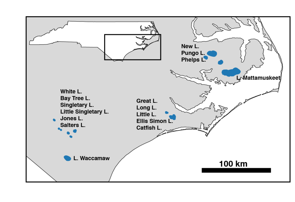
Tamlin Pavelsky, an associate professor of global hydrology in the UNC Department of Geological Sciences and an affiliate faculty of the Institute for the Environment, has built a career on measuring rivers and lakes. Until now, he has used satellite images to collect data on the surface area of these bodies of water. But, with a new grant from NASA, Pavelsky has the opportunity to combine that data with height measurements to gain a more accurate picture of water storage in lakes using citizen scientists in North Carolina.
Pavelsky’s new grant will allow him and a team to create a prototype citizen science program, enlisting North Carolinians to help collect height measurements on 15 lakes in the eastern part of the state. That data, combined with satellite measurements, will give a more accurate picture of water storage variations in lakes.
“We are focusing on understanding how the amount of water stored in lakes around the world changes over time,” Pavelsky said. “Getting the height of the water surface is a lot more challenging from space. But, it turns out that measuring variations in lake height is actually one of the easiest measurements to make on the ground.”
Pavelsky teamed up with IE’s Environmental Resource Program to create the prototype citizen science program. The program will test methods for recruiting and training citizen scientists, create new software to receive, process, and distribute citizen-collected lake stage data, and combine the citizen-collected stage data with lake area measurements automatically derived from NASA satellites to produce estimates of lake water storage.
“By tapping in to people’s interest in science all over the world, we get a lot more data that can validate assumptions,” says Kathleen Gray, director of IE’s Environmental Resource Program. “The beauty of the citizen science model is you have many more data collectors. We are no longer limited by one researcher and what his or her team can do.”
ERP’s Sarah Yelton, an environmental education coordinator, and Grant Parkins, a watershed education coordinator, will lead the citizen science portion of the program, leveraging their expertise in citizen science and science education with their connections in the state. They will work closely with the North Carolina State Parks and the North Carolina Museum of Natural Sciences.
“Citizen science is a wonderful way to connect North Carolinians with the cutting-edge research that is happening here at UNC-Chapel Hill,” says Parkins.
The prototype program will create a platform that anyone, anywhere in the world could install and be able to send measurements via smartphone app, Web site, or text message to Pavelsky’s team. The team will then create a data set for the lake showing how lake water storage varies over time.
“It is important to know what is happening with lakes because it tells us about the whole water cycle in a region,” says Pavelsky. “We simply don’t have the measurements to do that now and our goal is to try to fill that gap.”
These measurements will help discern how tightly connected water storage variations are in lakes within a region and illustrate how water moves around through the earth’s systems.
If the prototype phase is successful, NASA will fund an implementation phase, that will be used around the world.
Pavelsky is the lead hydrologist on a NASA satellite mission called SWOT (Surface Water and Ocean Topography), which will produce the first global survey of Earth’s surface water, observe the fine details of the ocean’s surface topography, and measure how bodies of water change over time. The satellite will launch in 2021.
This grant is administered by the UNC Institute for the Environment.