Listen to the story below:
At 6:35 a.m. on December 16, 2022, a small group gathers in the Martin Lounge at Mitchell Hall on UNC-Chapel Hill’s campus, sleepily shuffling around the donuts and coffee spread across a nearby table.
10 minutes to launch.
They slowly settle into yellow and green armchairs. Their attention turns to a giant TV, where they watch coverage of a SpaceX Falcon 9 rocket launch countdown from Vandenberg Space Force Base in California.
5 minutes to launch.
An electricity fills the room. Carolina research specialist Camryn Kluetmeier looks on with awe. Suddenly, her phone pings.
“Tamlin just messaged us!” she exclaims.
“We’re so close,” the message reads.
1 minute until launch.
Tamlin Pavelsky has waited for this moment for nearly two decades. Today, it could become a reality.
Liftoff.
The room grows quiet as the rocket cruises steadily upward. Within minutes, it breaches Earth’s atmosphere and settles into orbit. On December 20, 2022, four days after its initial launch into space, its large mast and panels finish unfolding, signaling that calibration can begin.
The Surface Water and Ocean Topography (SWOT) satellite is a collaboration between NASA and the French space agency. It will produce the first global survey of Earth’s surface water — and Pavelsky, a UNC-Chapel Hill researcher, is the freshwater science lead on the team. Surface water is essential for drinking and household use, agriculture, thermoelectric power, and numerous other industries. And SWOT can measure the height of all surface water to within 10 centimeters.


Using radar technology, the satellite sends a slew of pulses to Earth to create high-resolution images. It circumnavigates the planet every 21 days, drastically expanding our ability to collect data for large geographic regions and through poor weather like clouds and storms.
The data SWOT collects can measure how floodplains and wetlands change over time and the coastal processes related to fisheries, ship navigation, shoreline erosion, and pollutants. More simply, it will track changes in water movement and volume across the planet — critical information for areas hit hard by drought or flooding — and will help improve how we manage our water resources.
“This is a game-changer for our ability to understand how much water is flowing through rivers, how much water is stored in lakes and reservoirs, and how ocean circulation works,” Pavelsky says.
Pavelsky began working on the SWOT mission in 2004 when he was a PhD student at the University of California, Los Angeles. At the time, no mechanism existed to measure water level changes in all of Earth’s waterbodies. SWOT was the first conception of a way to complete this task — and is now the first to do it. Pavelsky was excited at the prospect of being part of such a life-changing mission.
“I don’t have kids,” Pavelsky says. “But I think of SWOT as my kid. It took 18 years to raise, and now it’s out of the house and off to college. Except, in this case, college is space.”
Upon SWOT’s successful voyage into space, Pavelsky and his team continued their preparations for an incredibly busy field season. Their first stop? New Zealand.
Navigating a complex maze
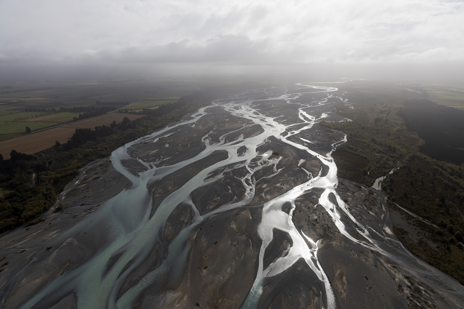
Fast-forward to April 5, 2023. Pavelsky, Kluetmeier, and PhD student Marisa Dudek cruise down the Waimakariri River — lovingly called the “Waimak” — on the South Island of New Zealand. At this point, SWOT has been spaceborne for 111 days, and Pavelsky’s team is conducting on-the-ground measurements to verify its accuracy.
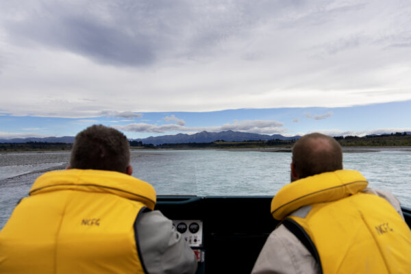
Steve Terry and Lyndon Slater from Fish & Game New Zealand guide the jetboat along the Waimakariri River toward the Southern Alps. (photo by Alyssa LaFaro)
The Waimak is a braided river, comprised of multiple streams that weave back and forth. It stretches over 90 miles from the base of the Southern Alps to the Pacific Ocean. When it rains, mountain sediment cascades into the river, disturbing the existing pathways by rerouting them in all directions. From above, it looks like one giant muddy trench, but underneath it’s a chaotic and evolving ecosystem.
Steve Terry, a jetboat driver from Fish & Game New Zealand, expertly navigates the complicated Waimak, warning the Carolina researchers when he needs to gun the motor to clear one of the river’s many gravel bars. At one point, he grounds the boat, and his second-in-command hops into the water and starts pushing.
“If we’re going to understand SWOT’s capabilities to measure rivers, we don’t just want to think about really nice, well-behaved rivers,” Pavelsky explains. “We also want to think about those poorly behaved, problem-child rivers. And the Waimakariri definitely falls into that category. It’s a challenging, interesting, difficult river.”
Each week, the research team mounted a GPS system to the top of the jetboat to measure the elevation of the water surface as they drove up and down the river. This was only possible on days when water levels were low, and rain wasn’t in the forecast.
But it’s just one of many ways they collected the data they sought. They also spent hours above the river — in the skies.
Flying precise lines
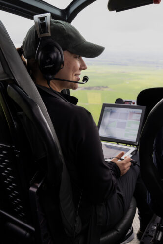
Marissa Dudek guides the pilot along precise GPS points to capture the LiDAR data. (photo by Alyssa LaFaro)
Pavelsky and his team worked with pilots from Christchurch Helicopters to attach a remote sensing device called LiDAR to the front of a helicopter to capture a high-resolution map of the landscape.
The LiDAR releases a laser and measures the time it takes for that light to hit the ground and return to the sensor. It does this repeatedly to create a detailed topographical map of the sand and gravel bars around the river and the surface of the water — and that’s exactly what SWOT is measuring, too.
But the LiDAR collection is tedious. The helicopter must stay within 1,200 to 1,500 feet above the landscape and fly extremely precise geographical lines to capture the data. To do this successfully, the researcher on board needs to track the flight path, verbally guide the pilot, and keep an eye out for nearby aircraft in the vicinity. This involves about seven hours of flight time in one day, which can cause dehydration and nausea.
For Dudek, motion sickness is well worth the data — and the views.
“The LiDAR collection is the most exciting part of the project,” she says with a laugh. “It’s going to be able to tell us the water surface elevation of the entire channel. Plus, seeing the Waimak from the helicopter is amazing.”
Dudek has a knack for modeling, writing code, and data analysis. This makes her an essential team member to help process the copious amount of data they’re collecting to validate SWOT.
“I think I bring a kind of fine detail to the research, thinking about the different projects we can do down the road with the data we’re collecting now.”
Savoring the data
Pavelsky and his team also installed a series of water-level loggers along the river to measure changes in height over time. With help from scientists at the University of Canterbury, they discovered a way to attach their sensors to a six-foot-long pipe and then bolt them to rocks along the river. This often involved wading along the edge of the Waimak until they found a spot that would work for their setup.
“We have such limited places along the river where we can install the sensors that wherever there’s a viable spot we have to try as hard as we can to get a sensor in,” Kluetmeier says.
Such work is precarious, requiring careful maneuvers over large slabs of bedrock. The nuts and bolts used to secure the pipe easily escape from pockets and hands, while the moving water and sandy riverbed make drilling into the rock unstable.
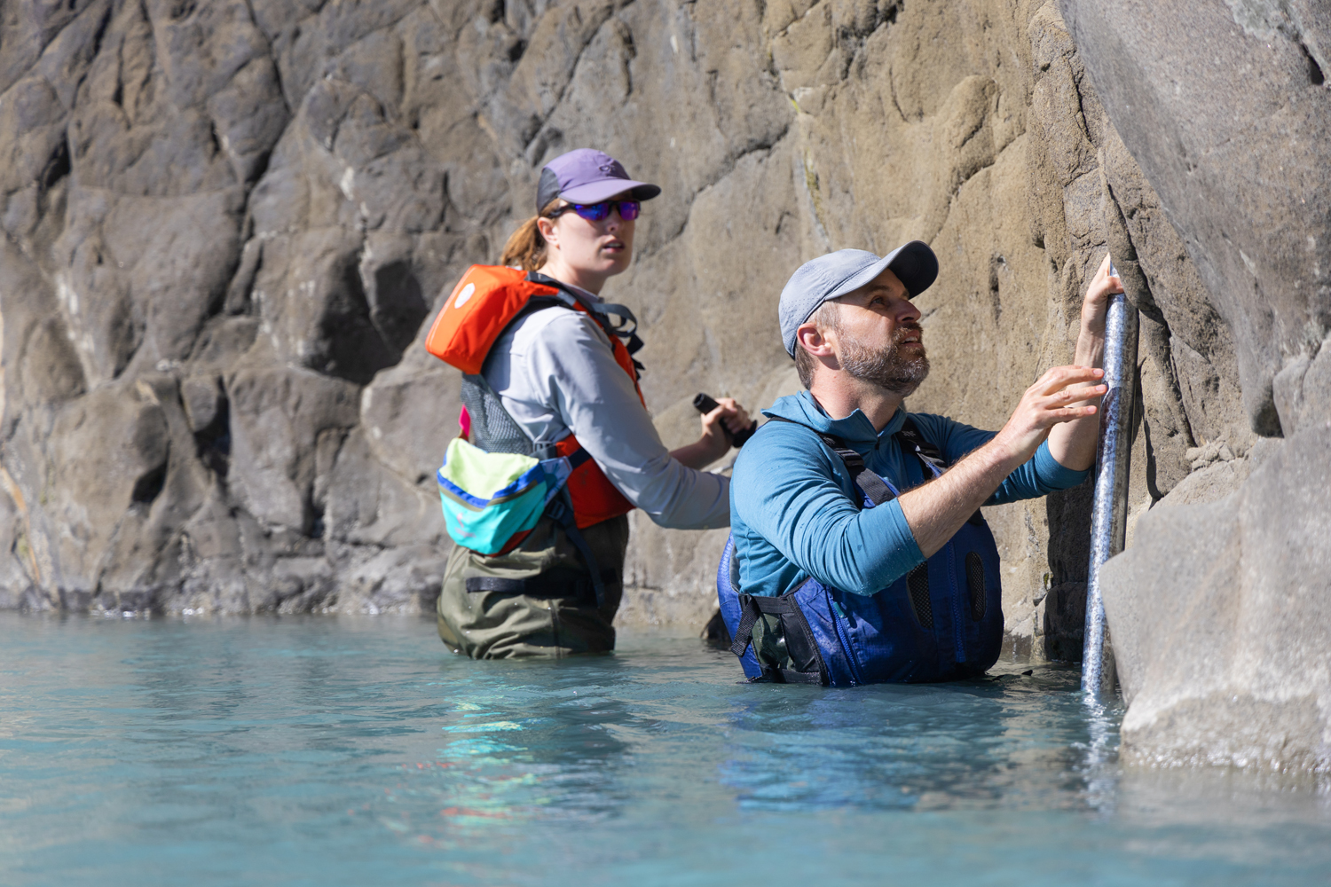
Camryn Kluetmeier and Tamlin Pavelsky install a water-level logger in the river. (photo by Alyssa LaFaro)
While navigating the Waimakariri River has been full of challenges, it’s just one of numerous field sites for the SWOT mission. Pavelsky’s team is also monitoring lakes and rivers in Alaska’s Yukon Flats, the Sierra Nevada in California, and across North Carolina. Other teams are collecting data in France, the U.K., Canada, Madagascar, Kyrgyzstan, and South America.
The images and data SWOT is producing are already exceeding expectations — information Pavelsky expects will lead to hundreds of new studies.
“SWOT is like a piñata we’ve whacked with a baseball bat and now all this candy is pouring out,” Pavelsky says, chuckling. “There are so many things we want to understand about Earth’s water that SWOT is going to enable — and scientists will be grabbing that candy for the next five years to figure out what it all means.”